
ธรรมชาติเชิงวิพากษ์: นอกเหนือจากการแบ่งปันข้อมูลน้ำร่วมกันแล้ว แม่น้ำหลานซาง-แม่โขง ยังต้องการธรรมาภิบาลน้ำที่รับผิดชอบ
/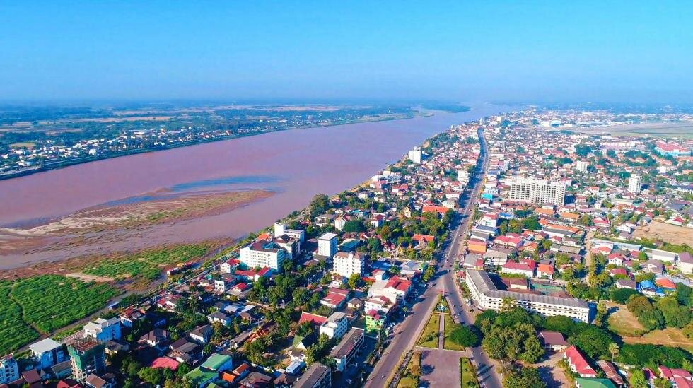
วิวแม่น้ำโขงที่มองจากเวียงจันทร์ ประเทศลาว (เครดิต: ภาพถ่ายจาก HEINRICH-BÖLL-STIFTUNG SOUTHEAT ASIA)
ในปี 2562 และอีกครั้งในปี 2563 แม่น้ำโขงหรือรู้จักในชื่อแม่น้ำหลานซางที่ตั้งอยู่ในประเทศจีน ได้ประสบกับปัญหาการไหลของกระแสน้ำที่ลดต่ำลง สิ่งนี้ได้สร้างความยากลำบากให้กับผู้คนนับล้านที่อาศัยอยู่ในบริเวณแม่น้ำดังกล่าว
เกิดการถกเถียงในระดับภูมิภาคอย่างเอาจริงเอาจังและแบ่งออกเป็นหลายฝักหลายฝ่ายเกี่ยวกับการลดลงของประแสน้ำอันเกิดจากความแห้งแล้งหรือผลกระทบจากการก่อสร้างเขื่อนขนาดใหญ่ที่ดำเนินการอย่างต่อเนื่องตลอดทั่วทั้งลุ่มน้ำตั้งแต่ปี พ.ศ. 2533 เป็นต้นมา สิ่งนี้ได้ส่งผลให้มีการเฝ้าติดตามและสนใจเป็นอย่างมากในการก่อสร้างเขื่อนไฟฟ้าพลังน้ำทั้ง 11 แห่ง ที่ตั้งอยู่บนลุ่มแม่น้ำสายหลักในประเทศจีนเนื่องจากขาดความโปร่งใสในการดำเนินงานก่อสร้างของโครงการเขื่อนและปริมาณการกักเก็บน้ำในอ่างเก็บน้ำ
ในเดือนเมษายน 2563 องค์กรที่ปรึกษาด้านการวิจัยที่ชื่อว่า อายออนเอิร์ธ (Eyes on the Earth) ได้ทำการเผยแพร่แบบจำลองกระแสน้ำตามธรรมชาติ (ก่อนที่จะมีการสร้างเขื่อน) ของแม่น้ำหลานซาง เพื่อคาดการณ์ผลกระทบของเขื่อนที่ตั้งอยู่ปลายน้ำในพื้นที่ภาคเหนือของประเทศไทย เนื่องจากไม่มีการตรวจสอบอย่างจริงจังในทรัพยากรสาธารณะอันเป็นที่ตั้งของสถานีวัดน้ำในประเทศจีน แบบจำลองทางสถิติ (Statistical Model) ได้ใช้ข้อมูลดาวเทียมเพื่อสร้าง “ดัชนีความเปียกชื้น” เพื่อคาดการณ์ปริมาณน้ำในอ่างกักเก็บน้ำและหลังจากนั้นจะนำผลที่ได้นี้ไปเชื่อมโยงกับการตรวจวัดระดับน้ำรายเดือนที่สถานีวัดน้ำใน อ.เชียงแสน ประเทศไทย โดยรวมแล้วการศึกษาครั้งนี้แสดงให้เห็นว่าตั้งแต่มีการก่อสร้างเขื่อนในแม่น้ำหลานซางที่ได้รับมอบอำนาจหน้าที่ให้ดำเนินการก่อสร้างในช่วงต้นปี 2533 ซึ่งระดับน้ำมีการลดระดับลงในช่วงฤดูฝนและเพิ่มสูงขึ้นในช่วงฤดูแล้ง การผิดปกติเพิ่มมากขึ้นและเกิดความผันผวนอย่างรวดเร็วในระดับน้ำทั้งในฤดูแล้งและฤดูฝน การเปลี่ยนแปลงเหล่านี้ปรากฏชัดตั้งแต่ปี 2555 เมื่อเขื่อนนัวจาตู้ (Nouzhadu) ที่มีกำลังการผลิตกระไฟฟ้าขนาด 5,850 เมกะวัตต์ เริ่มเติมน้ำเข้าไปในอ่างเก็บน้ำนั่นจึงทำให้เห็นว่าอ่างเก็บน้ำแห่งนี้มีปริมาณขนาดใหญ่กว่าทั้ง 4 เขื่อนที่สร้างขึ้นมาก่อนหน้านี้รวมกันเสียอีก
ในขณะที่ข้อสรุป (ความคิดเห็น) ต่างๆ เหล่านี้ได้มาจากการศึกษาทางวิทยาศาสตร์ที่ดำเนินการมาก่อนหน้านี้ รายงานที่จัดทำรายงาน นว่าEำเนินการมาก่อนหน้านี้ ทยาี่จะโดย Eyes on the Earth ได้รับความสนใจจากสื่อเป็นอย่างมากทั้งในระดับภูมิภาคและระดับนานาชาติเนื่องจากกลุ่มภาคประชาสังคมหลายกลุ่มรวมทั้งตัวแทนของรัฐบาลสหรัฐอเมริกาอ้างว่ามีหลักฐานชิ้นสำคัญที่บ่งชี้ว่ารัฐบาลจีนจะต้องแสดงความรับผิดชอบต่อปัญหาความรุนแรงจากภัยแล้งในช่วงระหว่างปี พ.ศ.2562 – 2563 อันเนื่องมาจากการ “ปิดก๊อก” หรือ กักตุนน้ำ” เพื่อเก็บไว้ใช้ของประเทศจีน ถ้อยแถลงการณ์เหล่านี้ได้นำไปสู่การโต้แย้งจากนักการทูตและนักวิจัยของจีนเป็นจำนวนมาก
การกล่าวอ้างที่สำคัญดังกล่าวนำไปสู่การตรวจสอบรายงานของ Eyes on Earth อย่างละเอียดถี่ถ้วน ได้แก่คณะกรรมาธิการแม่น้ำโขง (The Mekong River Commission: MRC) ออสเตรเลีย-ความร่วมมือแม่น้ำโขงเพื่อทรัพยากรสิ่งแวดล้อมและระบบพลังงาน (The Australia – Mekong Partnership for Environmental Resource and Energy Systems: AMPERES) และนักวิชาการที่ตั้งข้อสังเกตุถึงข้อจำกัดบางอย่าง เช่น ในรายงานได้แสดงให้เห็นถึงผลลัพธ์ของระดับน้ำแต่ไม่สามารถพิจารณาได้ว่าสิ่งนี้นั้นเทียบเท่ากับปริมาณน้ำ ไม่ได้บ่งบอกว่าจีนสามารถกักเก็บน้ำได้ทั้งหมดในช่วงฤดูฝน ด้วยเหตุนี้ ความสามารถในการยั้บยั้งการไหลของน้ำในแม่น้ำอย่างเต็มกำลังเป็นสาเหตุให้เกิดความแห้งแล้งในพื้นที่บริเวณปลายน้ำ และจะดีมากยิ่งขึ้นกว่าหากการศึกษาครั้งนี้ได้รับการทบทวนและตรวจสอบก่อนที่จะมีการเผยแพร่สู่สาธารณะ ยิ่งไปกว่านั้น นักวิจัยจาก AMPERES ได้กล่าวว่าการนำเสนอรายงานของ Eyes on Earth ในการอภิปรายสาธารณะบ่อยครั้งมักจะเกินกว่าการค้นพบที่แท้จริง ในเดือนกรกฎาคม 2563 นักวิจัยจากมหาวิทยาลัยชิงหฺวา (Tsinghua University) ซึ่งเป็นสถาบันวิจัยชั้นนำในประเทศจีนได้กล่าวเพิ่มเติมในข้อถกเถียงนี้ด้วยการศึกษาที่ระบุว่าภูมิภาคนี้ประสบปัญหาภัยแล้งอยู่ก่อนแล้ว อีกครั้งหนึ่งที่ AMPERES ได้ตรวจสอบการวิจัยนี้ซึ่งค้นพบว่าจำเป็นที่จะต้องมีการชี้แจงเพิ่มเติมเยอะมากขึ้นและข้อสรุปของการศึกษาเกี่ยวกับประโยชน์ของเขื่อนผลิตไฟฟ้าแบบขั้นบันได (Dam Cascade) ในประเทศจีนเพื่อบรรเทาภาวะภัยแล้งที่พื้นที่ปลายน้ำอาจทำให้เกิดการไขว้เขวได้
โดยรวมแล้วการศึกษาที่มีอยู่โดยทั้งหมดเกี่ยวกับผลกระทบของเขื่อนขั้นบันไดในประเทศจีนที่มีต่อประเทศปลายน้ำในขณะนี้มักอาศัยมักอาศัยข้อมูลที่ไม่สมบูรณ์ครบถ้วนเนื่องจากไม่สามารถเข้าถึงข้อมูลที่มีอยู่แล้วได้ ยิ่งไปกว่านั้นความแห้งแล้งในปี 2562 และ 2563 ยังเกิดขึ้นในช่วงเวลาที่ภูมิศาสตร์การเมืองทวีความรุนแรงมากขึ้นระหว่างสหรัฐอเมริกาและจีน ในเอเชียตะวันออกเฉียงใต้และทั่วโลก ในเดือนกันยายนปี 2563 ความร่วมมือลุ่มน้ำโขง-สหรัฐฯ (Mekong-U.S. Partnership: MUSP) ได้เปิดตัวขึ้นซึ่งพยายามที่จะกระชับความสัมพันธ์ระหว่างประเทศปลายน้ำและสหรัฐอเมริกาให้แน่นแฟ้นยิ่งขึ้น นั่นจึงทำให้จีนควบคุมทรัพยากรน้ำในลุ่มน้ำตอนบนด้วยความระมัดระวัง กระนั้นการทำให้เป็นการเมืองของงานวิจัยซึ่งมีข้อจำกัดของการศึกษาถูกลดทอนลงและผลลัพธ์ที่เปลี่ยนแปลงไปให้เป็นเรื่องเล่าที่เรียบง่ายนั้นมีความเสี่ยงที่จะทำลายความน่าเชื่อถือของหลักฐานทางวิทยาศาสตร์ที่สามารถบอกกล่าวได้ถึงกระบวนการกำกับดูแลน้ำข้ามพรมแดนตลอดจนกระบวนการตัดสินใจ
ในลุ่มน้ำหลานซาง-แม่โขง การกำกับดูแลน้ำข้ามพรมแดนมีความซับซ้อนเนื่องจากผลประโยชน์ที่หลากหลายของผู้มีส่วนได้ส่วนเสียทั้งจากรัฐและไม่ใช่รัฐ สถาบันหลักที่สำคัญทั้งสองแห่งที่วางกรอบโครงสร้างเพื่อการกำกับดูแลน้ำข้ามแดนที่มีระหว่างรัฐต่อรัฐ (State-to-State) ได้แก่ คณะกรรมาธิการแม่น้ำโขง (The Mekong River Commission: MRC) และ กรอบความร่วมมือแม่โขง-หลานซาง (Mekong – Lancang Cooperation: MLC) เกี่ยวกับสาเหตุของกระแสน้ำไหลช้าและภัยแล้งในปี 2562 เดือนธันวาคม 2562 LMC และ MRC มุ่งมั่นที่จะทำการศึกษาวิจัยร่วมกันว่าสถานภาพของการศึกษานี้จะไม่ได้ถูกประกาศต่อสาธารณะ คณะกรรมาธิการแม่น้ำโขง เป็นองค์กรตามสนธิสัญญาที่ก่อตั้งขึ้นในปี 2538 ระหว่างกัมพูชา ลาว ไทยและเวียดนาม กับ จีนและเมียนมา ในฐานะคู่เจรจา กรอบความร่วมมือแม่โขง-หลานซาง เปิดตัวขึ้นครั้งแรกในเดือนมีนาคม 2559 และรวมทั้ง 6 ประเทศของกลุ่มลุ่มแม่น้ำหลานซาง-แม่โขง โดยจีนมีบทบาทสำคัญในฐานะประธานร่วมและนักลงทุน และการจัดการทรัพยากรน้ำเป็น 1 ใน 5 ประเด็นสำคัญที่จะต้องดำเนินการ ในเวลาเดียวกัน MRC และ LMC ได้ร่วมมือและแข่งขันกันในการมีอำนาจหน้าที่ บทบาท และการมีอิทธิพลในลุ่มแม่น้ำโขง - หลานซาง
ในช่วงตลอด 2 – 3 ปีที่ผ่านมา การเรียกร้องอันยาวนานจากประเทศท้ายน้ำ ภาคประชาสังคมและชุมชนที่มีต่อจีนเพื่อการแบ่งปันข้อมูลน้ำทวีความรุนแรงมากขึ้น ตั้งแต่ปี 2539 เป็นต้นมา จีนได้มีการแบ่งปันข้อมูลเฉพาะข้อมูลฤดูฝน (มิถุนายน – ตุลาคม) และบางครั้งบางคราวจะมีการให้ข้อมูลฤดูแล้ในช่วงเวลา ‘ฉุกเฉิน’ ตามที่นักวิชาการ สจวร์ต บิบา (Stuart Biba) กล่าวว่ามันเป็นมาตราการเฉพาะกิจเพื่อลดการวิพากษ์วิจารณ์ ยิ่งไปกว่านั้น ข้อมูลที่ปล่อยออกมายังไม่สมบูรณ์เพียงพอที่จะสรุปได้อย่างชัดเจนถึงบทบาทของเขื่อนต้นน้ำที่มีบทบาทในการไหลของน้ำในแม่น้ำ ในบริบทของการวิพากษ์วิจารณ์ที่รุนแรงในช่วงปี 2563 ที่กล่าวถึงเมื่อตอนต้น ในวันที่ 22 ตุลาคม 2563 MRC ได้ประกาศว่าจีนได้ทำข้อตกลงที่จะแบ่งปันข้อมูลตลอดทั้งปี จำนวน 2 ครั้งต่อวัน สำหรับปริมาณน้ำฝนและระดับแม่น้ำจากสถานีวัดน้ำทั้ง 2 แห่งที่ตั้งอยู่ในเมืองม่านวาน (Manwan) และ จิงหง (Jinghong)
การเตรียมการใหม่สำหรับการแบ่งปันข้อมูลน้ำแบบรัฐต่อรัฐถือเป็นความก้าวหน้าที่สำคัญ รวมถึงการที่จีนได้เพิ่มความร่วมมือยิ่งขึ้นกับคณะกรรมาธิการแม่น้ำโขง ในการแบ่งปันข้อมูลมากกว่าการยืนกรานที่แบ่งปันข้อมูลผ่านกรอบความร่วมมือแม่โขง-หลานซาง อย่างไรก็ตาม ในแง่ของการแบ่งปันข้อมูลน้ำยังมีอีกมากที่ต้องทำเพื่อทำความเข้าใจสถานการณ์พื้นที่ต้นน้ำในประเทศจีน โดยเฉพาะอย่างยิ่งจำนวนสถานีตรวจวัดน้ำที่สามารถขยายให้ครอบคลุมเขื่อนไฟฟ้าพลังน้ำทั้งหมด 11 แห่ง ที่เปิดดำเนินการอยู่ในขณะนี้ และเพื่อการรวบรวมข้อมูลระดับน้ำทั้งพื้นที่ต้นน้ำและปลายน้ำ การไหลออกของอ่างเก็บน้ำแต่ละเขื่อนตลอดจนกำหนดการดำเนินการ นอกจากนี้ยังอาจรวมถึงข้อมูลน้ำในแม่น้ำสาขาซึ่งรวบรวมไว้อย่างครอบคลุม ในขณะที่การแบ่งปันชุดข้อมูลในอดีตสามารถช่วยสร้างเงื่อนไขก่อนหน้านี้ในลุ่มน้ำได้
อย่างไรก็ตาม สิ่งสำคัญคือต้องตระหนักว่ามีช่องว่างข้อมูลอื่นๆ อีกมากมายที่ต้องได้รับการแก้ไขในอ่างเก็บน้ำด้านล่าง ยกตัวอย่างเช่น จำเป็นที่จะต้องมีข้อมูลน้ำที่สมบูรณ์มากขึ้นเกี่ยวกับการดำเนินงานของโครงการสร้างเขื่อนในแม่น้ำสาขาที่มีผลต่อสภาวะน้ำท่วมและภัยแล้งทั้งในพื้นที่และสะสมตลอดทั้งลุ่มน้ำ สิ่งนี้ไม่ได้หมายถึงแต่เขื่อนไฟฟ้าพลังน้ำเพียงเท่านั้นแต่ยังรวมถึงแผนการชลประทานขนาดใหญ่ที่เพิ่มมากขึ้น นอกจากนี้ ยังมีความจำเป็นต้องมีการเปิดเผยข้อมูลต่อสาธารณะเกี่ยวกับผลกระทบของมาตราการบรรเทาความเสียหายที่เขื่อนไชยะบุรีที่เพิ่งสร้างเสร็จเมื่อเร็วๆนี้บนแม่น้ำสายหลักทางตอนเหนือของลาว เป็นสิ่งที่จำเป็น รวมทั้งการอพยพย้ายถิ่นของปลาและการเดินทางของตะกอน มีการริเริ่มโครงการภายใน MRC ตั้งแต่ปลายปี 2562 เพื่อศึกษาผลกระทบเหล่านี้ ในขณะที่องค์กรยังคงทำการรวบรวมข้อมูลอย่างมั่นใจแม้ว่าผลลัพธ์จะยังไม่เปิดเผยต่อสาธารณะก็ตาม การศึกษาเหล่านี้มีความจำเป็นอย่างเร่งด่วนในบริบทของ/และ ก่อนแผนการสำหรับโครงการกระแสหลักต่อไปซึ่งมี 4 โครงการที่กำลังได้รับการเสนออย่างจริงจัง การศึกษาเหล่านี้ยังสามารถช่วยอธิบายการเปลี่ยนแปลงของแม่น้ำที่ผิดปกติในรูปแบบอื่นๆ ที่เพิ่งสังเกตุได้ครั้งแรกในเดือนพฤศจิกายน 2562 และอีกหลายครั้งตั้งแต่นั้นเป็นต้นมา แม่น้ำโขงได้เปลี่ยนเป็นสีฟ้าน้ำทะเลในพื้นที่ของลาวและไทย ซึ่งโดยปกติแล้วจะเป็นสีน้ำตาลปนโคลน คณะกรรมาธิการแม่น้ำโขง ระบุว่าการสีที่เปลี่ยนนี้เกิดขึ้นจากการลดลงของปริมาณตะกอนและการเติบโตของสาหร่ายเนื่องจากการไหลของน้ำในแม่น้ำไหลต่ำ เป็นไปได้อย่างแน่นอนว่าการไหลของแม่น้ำในระดับต่ำและการเปลี่ยนแปลงของตะกอนจะเชื่อมต่อกับเขื่อนที่เพิ่งสร้างขึ้นมา
เมื่อวันที่ 13 พฤศจิกายน ปีนี้ คณะกรรมาธิการแม่น้ำโขง ได้ประกาศปรับปรุงเว็ปไซต์และ “ศูนย์รวมข้อมูล(Data Portal)” โดยมีเป้าหมายที่ระบุไว้คือ " (การ) ส่งเสริมความโปร่งใส เพิ่มการเข้าถึงข้อมูลและความรู้ที่เกี่ยวข้องกับแม่น้ำโขง" ตามข่าวประชาสัมพันธ์ของ คณะกรรมาธิการแม่น้ำโขงศูนย์รวมข้อมูลมีสิ่งพิมพ์มากกว่า 1,000 รายการโดย MRC เองและมากกว่า 10,000 ชุดข้อมูลเกี่ยวกับข้อมูลอนุกรมเวลาทางอุตุนิยมวิทยาทั้งในปัจจุบันและในอดีต แผนที่เชิงพื้นที่ แผนที่ ภาพถ่ายและชุดข้อมูลภาค ความพร้อมใช้งานของข้อมูลนี้จะเป็นทรัพยากรที่มีค่าสำหรับนักวิจัย รวมทั้งคณะกรรมาธิการแม่น้ำโขงก็เช่นกัน ในกลยุทธ์การสนับสนุนศูนย์รวมข้อมูลเน้นความสำคัญของข้อมูลดิบและการวิเคราะห์ผ่านการสร้างแบบจำลองและการพยากรณ์
ถึงกระนั้น ยังมีขั้นตอนสุดท้ายที่สำคัญที่จะต้องดำเนินการนั่นคือ การเชื่อมโยงความพร้อมใช้งานของข้อมูลน้ำที่ครอบคลุมมากขึ้นซึ่งสามารถเพิ่มความโปร่งใสในการปรับปรุงการกำกับดูแลน้ำข้ามแดนที่มีส่วนร่วมและรับผิดชอบต่อชุมชนที่อาศัยอยู่บนฝั่งแม่น้ำ ภาคประชาสังคมและสาธารณชนในวงกว้าง สิ่งนี้นำไปประยุกต์ใช้ในลุ่มน้ำตอนล่าง ยกตัวอย่างเช่น การปรึกษาหารืออย่างต่อเนื่องเกี่ยวกับเขื่อนหลักที่เสนอและเกี่ยวข้องกับการประกาศของจีนที่จะเพิ่มการแบ่งปันข้อมูลที่ยังไม่ได้เชื่อมโยงอย่างชัดเจนกับความมุ่งมั่นที่จะปรับปรุงความรับผิดชอบของโรงไฟฟ้าพลังน้ำแบบขั้นบันไดในแม่น้ำหลานซางไปยังประเทศปลายน้ำและชุมชนที่ตั้งอยู่ริมแม่น้ำ
สิ่งสำคัญคือต้องตระหนักว่าประเภทของความรู้ทางวิทยาศาสตร์ที่คิดค้นโดยคณะกรรมาธิการแม่น้ำโขงและนักวิจัยทางวิทยาศาสตร์เป็นเพียงรูปแบบเดียวของความรู้ที่จำเป็นสำหรับการพัฒนาที่ครอบคลุมและยั่งยืน การตั้งอยู่บนความรู้ของชุมชน เช่น งานวิจัย “ไทบ้าน” ซึ่งเป็นงานวิจัยที่นำโดยชุมชนตลอดจนรูปแบบความรู้ทางการเมืองและการปฏิบัติทุกเรื่องเพื่อให้ความรู้สามารถ “นำไปปฏิบัติได้” การเติบโตล่าสุดของ “การร่วมผลิตความรู้” หรือ “การวิจัยแบบสหวิทยาการ” สะท้อนให้เห็นถึงการยอมรับถึงการตัดเชื่อมต่อระหว่างความรู้ทางวิทยาศาสตร์ก่อนหน้าและผลกระทบต่อการกำกับดูแลสิ่งแวดล้อมที่ดีขึ้น การเรียกร้องให้มีการยอมรับมากขึ้นถึงความชอบธรรม คุณค่า จุดแข็งและข้อจำกัดของการผลิตความรู้ที่กว้างขึ้นและเพื่อความรับผิดชอบร่วมกัน ในบริบทของการข้ามพรมแดนแม่น้ำหลานซาง-แม่โขง สิ่งสำคัญคือ ผู้ที่ผลิตองค์ความรู้ที่หลากหลายต้องเป็นเครือข่าย มีการติดต่อสื่อสารและการปรึกษาหารือข้ามพรมแดน
การตั้งอยู่บนหลักการของการแบ่งปันความรู้และการสร้างสรรค์ร่วมกัน มีความจำเป็นที่จะต้องมีระบอบการปกครองที่อิงกฎเกณฑ์ที่ชัดเจนและเป็นสถาบันสำหรับลุ่มน้ำหลานซาง – แม่โขง ทั้งหมดซึ่งอยู่บนพื้นฐานของการสนทนาที่มีความหมาย ความสัมพันธ์และความไว้วางใจระหว่างรัฐกับชุมชนและภาคประชาสังคม อนุสัญญา Watercourses ของสหประชาชาติระบุหลักการและแนวปฏิบัติที่ดีสำหรับสิ่งนี้ รวมถึงวิธีการจัดการความซับซ้อนของความรู้และความไม่แน่นอนที่เกี่ยวข้องกับหลักการ “ห้ามทำให้เกิดอันตราย” และ “ข้อควรระวัง” โดยมุ่งเน้นไปที่การกำหนดแนวทางตามกฎเกณฑ์ในระดับประเทศและระดับข้ามแดนอันเป็นกลไกสำคัญที่ทำให้เกิดความรับผิดชอบและยังอยู่ในวิสัยทัศน์ที่เป็นทางเลือกสำหรับลุ่มแม่น้ำโขง-หลานซางที่จะสามารถสำรวจและพิจารณาอย่างจริงจังอีกด้วย
———
[1] ผู้อำนวยการศูนย์เชี่ยวชาญการเมืองเพื่อการพัฒนาสังคม ศูนย์ศึกษาการพัฒนาสังคม คณะรัฐศาสตร์จุฬาลงกรณ์มหาวิทยาลัย Email: Carl.Chulalongkorn@gmail.com
บทความนี้เผยแพร่ครั้งแรกบนเว็บไซต์ Heinrich-Böll-Stiftung Southeast Asia เมื่อวันที่ 27 พฤศจิกายน 2020 สามารถเข้าไปดูได้ที่ลิงค์ (link) นี้