

Finding Common Ground: Co-produced Wetland Zoning in Northeast Thailand
/By Kanokwan Manorom, Surasom Krisanachuta and Carl Middleton

Wetland survey in Nong Kae Sub-district (Credit: Phongtep Bungkla)
In 1993, on the Mun River in Si Sa Ket Province, Northeast Thailand, an irrigation weir called Rasi Salai was built that would lead to almost two decades of at times intense conflict between the communities whose livelihoods were harmed by the project and the government agencies that built and operated it. Since the late 2000s, however, the conflict has gradually thawed as a participatory social impact assessment was produced supported by the Royal Irrigation Department (RID), the government partly compensated affected communities, and negotiations began on how lost livelihoods could be recovered.
In this context, the RECOVER project in Northeast Thailand, led by the Mekong Sub-Region Social Research Center (MSSRC), Ubon Ratchathani University and with support from SUMERNET, has worked together with community leaders and affected villagers, community-based organizations and non-government organizations, local authorities, and government officers from RID and the Office of Natural Resource and Environment in a collaborative wetland mapping project. The project addresses a self-identified goal agreed upon amongst the project partners to clearly categorize a wetland area affected by the Rasi Salai dam, and designate permitted uses within it which may range from rice and cassava growing, to fish or forest conservation areas.
Rubber turns to concrete
When villagers first heard about plans for the Rasi Salai dam in 1990, they were led to believe that it would be a 4.5 meter high inflatable “rubber weir” to help address problems with seasonal water shortage. As construction proceeded, however, it became apparent that the actual project was a nine meter high concrete dam. The project, built without an Environmental Impact Assessment, created a reservoir of 10,000 hectares inundating farmland and wetlands. As the actual form of the project became apparent, NGOs and villagers began to organize to oppose the project, but were too late to prevent its construction
Before the project’s construction, the communities’ livelihoods and culture were intimately tied to the Mun River’s wetlands, including for rice and other crop production, cattle grazing, and for the collection of medicinal plants, valuable mushrooms, red ant eggs, fire wood, and grasses for weaving. The prolonged seasonal inundation produced by the reservoir severely disrupted this way of life, including the communities’ ability to raise cattle, as well as to grow wetland rice and other crops. Fish catch also dropped as the dam disturbed the ecosystem and its migratory fish species. These changes placed pressure on traditional forms of community collaboration that emerged from shared work around the wetland resources.
In total, between 15,000 and 17,000 people in Si Sa Ket, Surin and Roi Et provinces were affected by the project (Coddington et al, 2010). Meanwhile, the actual achievement of the project has been questioned. Whilst originally planned to irrigate 5,500 hectares and thus allow two crops per year (Living Rivers Siam Association, 2000), the project was only able to irrigate an estimated 1,600 hectares (SEARIN et al, 1999). Furthermore, the project ran six times over its original budget.

Monthly meeting of the Tam Mun Association, August 5th, 2015 (Credit: Carl Middleton)
In response, the affected communities organized themselves and also partnered with the Assembly of the Poor movement. They regularly protested the dam, including organizing protest marches, camping outside parliament and government offices in Bangkok, and occupying the dam site itself. Since 1997, the government had promised to assess and compensate the villagers, but these promises were slow to materialize.
Because much of the wetland area used by the community was managed under traditional tenure arrangements without formal land title, and was also argued by the government agencies to be state land rather than under community ownership, loses were at first not acknowledged by the government. Further compounding the dispute, baseline data had not been collected before the project was constructed. Yet, following a prolonged occupation of the dam site for 189 days in 2007, villagers finally received a compensation of 32,000 baht per rai for some areas of land. Other losses claimed by the communities, however, still remain uncompensated for.
Meanwhile, in 2009, a community Participatory Social Impact Assessment (PSIA) was published, originally commissioned in 2000, that was produced as a collaboration between the Assembly of the Poor, state officials, and academics including from Ubon Ratchathani University, Khon Kean University and Suranaree University of Technology. The report put forward a number of recommendations to restore the region to the best available options. These included: activities to recover degraded wetlands for food security and ecological services, establish local development activities including organic agriculture and a green market, and promote integrated farming systems and fish conservation, and media on wetland conservation.
Guided by the PSIA, sixteen government line agencies are now receiving funding to undertake activities related broadly to wetland recovery. Whilst the mobilization of state resources to resolve the impacts is commendable, there is presently limited coordination with and accountability to the affected communities themselves. Meanwhile, the Rasi Salai communities are still waiting to have their own recovery project proposals approved by the government.
Despite these challenges, since the late 2000s, as the government began to issue compensation, the affected communities decided to shift their strategy and turned to principally negotiating with RID to recover their livelihoods. They formed the Taam Mun Association (TMA) whose membership are the communities affected by the Rasi Salai Dam, together with a second dam called Hua Na which is located relatively nearby. The RID provided 30 rai of land to the TMA and a grant to build a community learning center to share community knowledge. The members of the TMA meet monthly, and alongside their actions that continue to pressure the government to provide complete compensation, they also support various activities including a village saving fund, a network of farmers producing organic agriculture, and a weekly “green market” in Rasi Salai district town.
Conflict resolution through knowledge co-production
Recognizing the desire amongst the Tam Mun Association, NGOs, representatives from Sub-district Administrative Organizations (Or Bor Tor) and village heads, and officers from both the RID and the Office of Natural Resources and Environment to reduce tension and resolve this now longstanding dispute, the RECOVER project team began by exploring individually with them their visions and priorities for wetland recovery. This informed a workshop, held in March 2015, where representatives from each shared their ideas, and identified common ground upon which to build collaboration.
At this workshop, participants agreed that: 1) wetlands have been dramatically declining both in terms of quantity and quality; 2) there is a lack of coordination between potential partners to manage and recover wetlands; 3) there is still a knowledge gap about baseline data on the wetland both in terms of bio-physical and socio-economic data; and 4) there remain challenges on how to manage and recover wetlands that have been compensated by RID, as many villagers have continued to use the areas.
The workshop participants agreed upon a shared goal to recover impacted wetlands, with a priority on areas that had already been compensated for by the government. This led to a proposal to collaboratively zone these areas of wetland and develop rules for their use, thus establishing a “community wetland” that balances community use with conservation objectives. Following a series of further individual meetings, a second workshop held in April 2015 agreed that this collaborative zoning would be undertaken in Nong Kae Sub-district on the Mun River and partly on Naam Seiw River, which is a tributary to the Mun River.

Water melon production in wetlands alongside the reservoir (Credit: Carl Middleton)
The process of collaborative zoning draws upon and synthesizes the diverse knowledge of those involved, ranging from GIS techniques by the government agencies, to knowledge of local ecosystems and their uses amongst the communities who live around and utilize in various ways the wetlands. A step-by-step process was agreed upon to be jointly undertaken that included: map production based on data held by Office of Natural Resources and Environment followed by a review and first-round verification with villagers and local authorities; physical surveys and classification of ecosystems according to size, users and purposes of use; identification of any wetland changes and the cause of these changes; socio-economic surveys of livelihoods related to wetland use; documentation of villager uses of areas that have been already compensated by RID and thus are in principle state property; and documentation of any existing customary rules and participatory arrangements of villagers.

GIS map presented by the Office of Natural Resources and Environment at the RECOVER workshop on 8 April 2015 (Credit: Phontep Bungkla)

Dr. Kanokwan Manorom and Dr. Surasom Krisanachuta at the RECOVER workshop on 8 April 2015 (Credit:Phontep Bungkla)
Following further detailed discussions amongst village leaders in Nong Kae Sub-district and the preparation of research tools, from June 20 to 22, 2015 villagers, government staff and RECOVER team members worked together to undertake the resource mapping. Three zones were mapped: 1) upstream of the dam, in the flooded zone and non-flooded zone; 2) downstream of the dam; and 3) beyond the Nong Kae Sub-district area where villagers utilize natural resources.
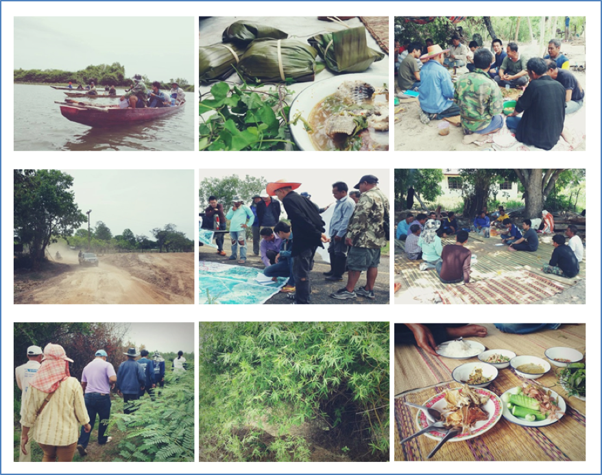
Wetland survey in Nong Kae Sub-district (Credit: Phongtep Bungkla)
At a subsequent meeting on 10th July 2015, the team members came together again to verify the field survey data. They also prepared a plan to be undertaken by the end of 2015 which includes: detailed physical and socio-economic surveys in each village of Nong Kae Sub-district through a Participatory Action Research process; and the identification of potential activities to be included within the zoning that could include ecological conservation, community fishery zone, indigenous sweet potato zone, community grazing area, eco-tourist spots, community rice farming, community special tree planting (Poo Pii Tree) for cattle, and community sand mining.
Given the past history of conflict in the area, the project partners are proud and pleased so far to be a part of the field survey as they have never made this happen before. For the government officers and representatives of the Nong Kae Or Bor Tor and village leadership, they agreed that participation in the survey had allowed them to gain more insight and understanding about what had been happening in the area, including the natural beauty, uniqueness and richness of the area’s resources which could have a high potential for ecotourism, as well as the degradation caused by the operation of the Rasi Salai dam and other overuse of resources. For the affected villagers and the Taam Mun Association, they are glad to reduce tension experienced with the RID in the past and to deepen their collaboration with the Or Bor Tor.
Whilst many challenges remain to be overcome, the collaborative wetland zoning to date has helped all participants find new common ground, and to take steps towards a shared goal of wetland recovery.
References
Coddington, C., Dixon, L., Friedman, C., Gaias, L., Kam, A., Makadia, B., Mendell, J., O'Bray, L., Pukinskis, I., Saekow, A., and Sosa, E. 2010. A Collaborative Community Consultation Report: Rasi Salai Dam. Published by CIEE, Khon Kaen University.
Living River Siam Association. 2000. “Rasi Salai Dam.” http://www.livingriversiam.org/3river-thai/rs_en.htm
Molle, F., P. Floch, et al. (2009). The 'Greening of Issan': Politics, Ideology and Irrigation Development in the Northeast of Thailand. in Contested Waterscapes in the Mekong Region: Hydropower, Livelihoods and Governance. F. Molle, T. Foran and M. Käkönen. London, Sterling, VA, Earthscan: 253-282.
SEARIN, The Committee to Save Tam Mun, Assembly of the Poor, & Wildlife Fund Thailand. 1999. “Basic information about Rasi Salai dam.” Living River Siam Association. April 20, 1999. Chiang Mai, Thailand.